


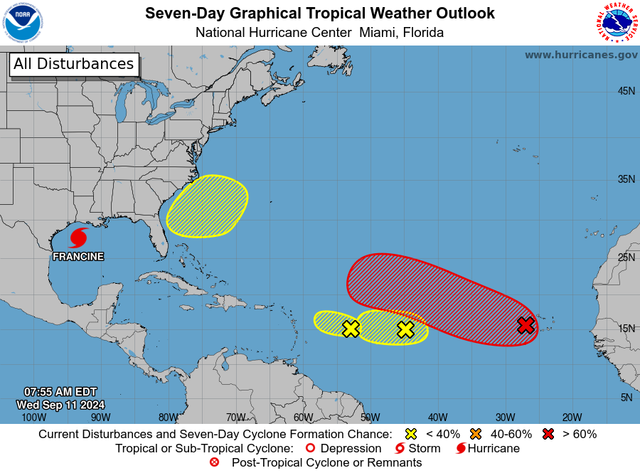

Tropical Weather Outlook- NWS National Hurricane Center Miami FL 800 AM EDT Wed Sep 11 2024

Eastern and Central Tropical Atlantic (AL93):
Showers and thunderstorms are showing signs of organization with a tropical wave located a few hundred miles to the west-southwest of
.tdi_2.td-a-rec{text-align:center}.tdi_2.td-a-rec:not(.td-a-rec-no-translate){transform:translateZ(0)}.tdi_2 .td-element-style{z-index:-1}.tdi_2.td-a-rec-img{text-align:left}.tdi_2.td-a-rec-img img{margin:0 auto 0 0}@media (max-width:767px){.tdi_2.td-a-rec-img{text-align:center}}

the Cabo Verde Islands.

Environmental conditions appear favorable for additional development of this system, and a tropical depression is likely to form over the next few days as the system moves
west-northwestward at 10 to 15 mph into the central Tropical Atlantic.

* Formation chance through 48 hours…medium…50 percent.
* Formation chance through 7 days…high…90 percent.

Central Tropical Atlantic (AL92):

An elongated area of low pressure located over the central tropical Atlantic continues to produce some disorganized shower and
thunderstorm activity. Environmental conditions appear marginally conducive for some slight development during the next day or two
while the system moves westward at 5 to 10 mph over the central tropical Atlantic.
The disturbance is expected to reach an area of
stronger upper-level winds on Thursday, likely ending its chances for development.
* Formation chance through 48 hours…low…30 percent.
* Formation chance through 7 days…low…30 percent.
3. East of the Leeward Islands:
A small but well-defined area of low pressure located several hundred miles to the east of the Leeward Islands is producing an
area of disorganized showers and thunderstorms. The proximity of dry air near the system is expected to limit additional development over
the next couple of days before environmental conditions become even less conducive by this weekend as it moves slowly
west-northwestward.
* Formation chance through 48 hours…low…10 percent.
* Formation chance through 7 days…low…10 percent.
4. Offshore the Southeastern U.S. over the Western Atlantic:
In a few days, a non-tropical area of low pressure could form along a residual frontal boundary a few hundred miles off the southeastern
U.S. coastline.
Thereafter, some subtropical or tropical development is possible during the early part of next week as the system
meanders over the Gulf Stream or drifts slowly northward.
* Formation chance through 48 hours…low…near 0 percent.
* Formation chance through 7 days…low…20 percent.
Forecaster Papin
Advertise with the mоѕt vіѕіtеd nеwѕ ѕіtе іn Antigua!
We offer fully customizable and flexible digital marketing packages.
Contact us at [email protected]