


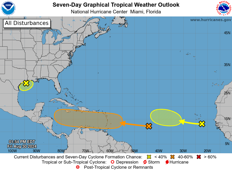

Near the Lesser Antilles and Caribbean Sea:

Showers and thunderstorms associated with a tropical wave over the
central tropical Atlantic remain disorganized. Gradual development
.tdi_2.td-a-rec{text-align:center}.tdi_2.td-a-rec:not(.td-a-rec-no-translate){transform:translateZ(0)}.tdi_2 .td-element-style{z-index:-1}.tdi_2.td-a-rec-img{text-align:left}.tdi_2.td-a-rec-img img{margin:0 auto 0 0}@media (max-width:767px){.tdi_2.td-a-rec-img{text-align:center}}

of this system is possible during the next few days, and a tropical

depression could form some time next week while it moves westward,
reaching the Lesser Antilles on Monday and continuing across the

Caribbean Sea through the middle to latter part of the week.
* Formation chance through 48 hours…low…near 0 percent.

* Formation chance through 7 days…medium…40 percent.

3. Eastern Tropical Atlantic:
Another tropical wave between the west coast of Africa and the Cabo
Verde Islands is producing minimal shower and thunderstorm
activity. Some slow development of this system is possible through
late next week while it moves slowly to the west-northwest over the
eastern and central tropical Atlantic.
* Formation chance through 48 hours…low…near 0 percent.
* Formation chance through 7 days…low…20 percent
Advertise with the mоѕt vіѕіtеd nеwѕ ѕіtе іn Antigua!
We offer fully customizable and flexible digital marketing packages.
Contact us at [email protected]